Parcel Boundaries, Right Inside Google Earth Pro
Cancel anytime. No long-term commitment.
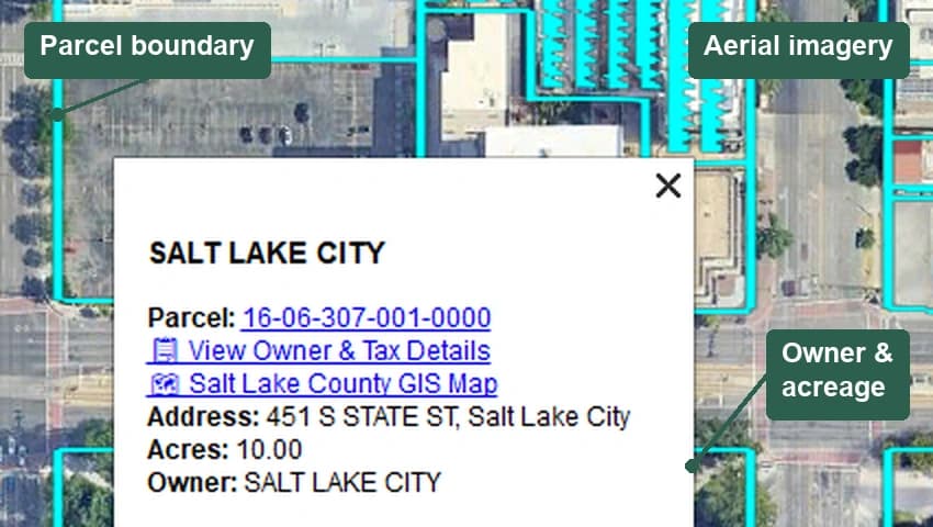
Parcel boundaries on aerial imagery in Google Earth Pro. Subscribe, open one link, and start exploring. Click a parcel to see its data. What appears depends on the county.
How It Works
Get started in three simple steps.
Subscribe
Sign up in under a minute for $10/month.
Open Your Link
Paste your personal link into Google Earth Pro. No plugins, no downloads.
Explore Parcels
Pan and zoom anywhere in Utah. Parcel data loads automatically as you move.
Everything You Need
Powerful parcel data, delivered seamlessly to Google Earth Pro.
Parcel Boundaries on Aerial
See every property line overlaid on satellite imagery.
Click a Parcel for Its Data*
Click a parcel to see its data. Owner, address, acreage, and value each show where the county supplies them.
Monthly Data Refresh
Parcel data refreshes monthly from the county sources.
All 29 Utah Counties
From Salt Lake to San Juan, every county is covered.
Beyond Utah
Arizona, Colorado and Idaho counties are included too.
Salt Lake County Zoning Overlay
A zoning overlay for Salt Lake County exists and is off by default. Switch it on from the layer list if you need it.
*Ownership and property data availability varies by state and county, and depends on the information supplied by each county.
Built for Professionals
Whether you're investing, appraising, or planning — Cartographer gives you the data you need.
Real Estate Investors
Find parcels on the aerial photo and click for data. Owner, acreage, and value each show where the county supplies them.
Appraisers
Overlay parcel boundaries on aerial imagery to verify property lines and assess comparable sales.
Title & Escrow Officers
Click a parcel for its data and a path to the county records, where the county supplies them.
Developers & Planners
Visualize land parcels, acreage, and property data to plan projects with confidence.
All 29 Utah Counties, Covered
Utah has 29 counties. Every one of them is in Cartographer — find yours below.
- Beaver
- Box Elder
- Cache
- Carbon
- Daggett
- Davis
- Duchesne
- Emery
- Garfield
- Grand
- Iron
- Juab
- Kane
- Millard
- Morgan
- Piute
- Rich
- Salt Lake
- San Juan
- Sanpete
- Sevier
- Summit
- Tooele
- Uintah
- Utah
- Wasatch
- Washington
- Wayne
- Weber
What We Cover, State by State
Exact county counts and what each state carries — no guesswork.
- Utah29 of 29 counties1.8M+ parcels
- Parcel boundaries. Owner, acreage, and value each show where the county supplies them. Salt Lake County has a colour-coded zoning overlay, off by default.
- Colorado44 of 64 counties2.5M+ parcels
- Parcel boundaries. Owner, acreage, and value each show where the county supplies them.
- Arizona4 of 15 counties2.3M+ parcels
- Parcel boundaries. Owner, acreage, and value each show where the county supplies them.
- Idaho44 of 44 counties1.1M+ parcels
- Parcel boundaries, ownership records and a zoning designation where the county supplies it. Property values are not available in Idaho.
Utah parcels of one acre and up are switched on the first time you open Cartographer. Colorado, Arizona and Idaho, parcels under an acre in the states listed above, and the Salt Lake County zoning overlay are included, and you switch them on from the layer list in Google Earth. The zoning designation on an individual parcel needs no switching — it shows with that state's parcels, wherever the county supplies it. Loading only the layers you've asked for is what keeps Google Earth quick.
Utah parcel boundary and property data sourced from Utah's statewide GIS parcel layers. Ownership and property-field availability varies by state and county.
Simple, Transparent Pricing
One plan. Everything included. No surprises.
Cartographer
Cancel anytime
- All 29 Utah counties
- Parcel boundaries on aerial imagery
- Ownership & property data*
- Market values where counties publish them
- Automatic data updates
- Arizona, Colorado & Idaho counties included
*Ownership and property-field availability varies by state and county, and depends on the information supplied by each county.
Frequently Asked Questions
Everything you need to know about Cartographer.
Cartographer is a Google Earth Pro overlay for Utah, Arizona, Colorado, and Idaho. Subscribe, open one link, and parcel boundaries draw on the aerial photo. Click a parcel to see its data. What appears depends on the county. It is an illustration. Confirm the line and the numbers with the county. All 29 Utah counties are on by default. Arizona, Colorado, and Idaho layers start off until you switch them on.
No additional plugins or software are needed. You just need Google Earth Pro (free from Google) and your Cartographer subscription link. Paste the link, and parcels appear automatically.
Every parcel includes boundaries on aerial imagery. Click a parcel to see its data. Owner, address, acreage, and value each show where the county supplies them. It is an illustration. Confirm the line and the numbers with the county.
Parcel data refreshes monthly.
All 29 Utah counties, plus counties in Arizona, Colorado, and Idaho. Utah is on by default. Arizona, Colorado, and Idaho layers start off until you switch them on in Google Earth.
The colour-coded zoning overlay is Salt Lake County only, and it is off by default. Switch it on from the layer list in Google Earth Pro. Parcel boundaries remain available in the counties we cover. Field availability varies by state and county.
Utah, Arizona, Colorado, and Idaho are included today. There is no announced timeline for other states.
You can update your payment method or cancel your subscription anytime through the billing portal. Just enter the email address you used when subscribing. Go to subscription management.
You will be charged $10 when you subscribe, and then monthly after that. You can cancel anytime. No contracts or commitments.
Start Exploring Utah's Parcels Today
Join professionals across Utah who rely on Cartographer for fast, accurate parcel data.